Trans Libia 99 4x4 Rally
 Esta página sirve de soporte rápido para el acontecimiento 'Trans Libia 99' 4x4.
Alrededor de unos 40 participantes de Espańa y Portugal cruzarán a través de los
desiertos de Tunez y Libia. José Ramos, el 'experto en GPSS' en Portugal, puso
a Oscar Hernández en contacto con Robin. El primer contacto via e-mail fue el lunes
8 de Marzo, pero se ha progresado con rapidez. Robin está muy agradecido a todos
aquellos que que están ayudando para que la viabilidad y la precisión de las capturas
topográficas esté dispomible a tiempo para que todos los participantes puedan usar
GPSS de forma gratuita - aunque solo sea para que vuelvan a casa.
Esta página sirve de soporte rápido para el acontecimiento 'Trans Libia 99' 4x4.
Alrededor de unos 40 participantes de Espańa y Portugal cruzarán a través de los
desiertos de Tunez y Libia. José Ramos, el 'experto en GPSS' en Portugal, puso
a Oscar Hernández en contacto con Robin. El primer contacto via e-mail fue el lunes
8 de Marzo, pero se ha progresado con rapidez. Robin está muy agradecido a todos
aquellos que que están ayudando para que la viabilidad y la precisión de las capturas
topográficas esté dispomible a tiempo para que todos los participantes puedan usar
GPSS de forma gratuita - aunque solo sea para que vuelvan a casa.
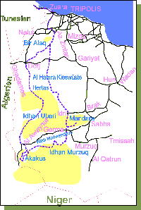
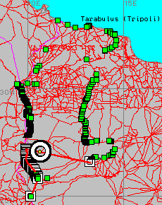
El mapa de la derecha de Oscar, mostrando la ruta.
Desgraciadamente Robin solo habla inglés, por eso puede que quieras contactar con otros que hablen Portugués o Espańol. José Ramos, un 'experto en GPSS' se presta a ello en jose.ramos@mail.telepac.pt. José está en Lisbon cerca de 384800N0091140W, y tiene un Garmin 12XL. José vende cables para Garmin, los detalles pueden verse en Jose's Garmin Cable Page
Oscar es un nuevo contacto de Robin, incluiremos más detalles aquí. De momento podemos decirte que Oscar vende sistemas GPS Garmin, y se puede contactar por e-mail en sottaventura@mail.telepac.pt
El software GPS en sí mismo debe descargarse y probarse con tu GPS y tu cable, antes de que ańadas mapas de Espańa, Portugal, Tunez o Libia. Debes ponerte en contacto con Robin por e-mail, con respuestas a 'Quiz Free Registration' en la misma GPSS Download Page para conseguir una clave de 'supresión del Snoopy'
Si lo deseas, Robin te ańadira a la lista de enlaces de su página GPSS Links Page and this page. La mayoría de la gente que ayuda a probar GPSS y nuevos mapas - lo mejor.
Debes aprender como usar GPSS ahora - antes de abandonar Espańa o Portugal. Encontrarás mapas para GPSS de Espańa y Portugal en European Download Page
Ahora bien, esta página se utiliza para que haya una comprensión común de la información básica tal como la ruta, y el emplazamiento de los puntos relevantes (waypoints). Los mapas de Tunez y Libia están disponibles en African Download Page y esperamos cargar mapas a medida para el acontecimiento 'Trans Libya 99'.
 Oscar escribió a Robin un fichero TXT de Waypoint+ el martes 9 de Marzo
(guardado como OSCAR2.TXT), y Robin recibió respuestas de varios contactos sobre el formato
de este fichero (e.g. latitud de 35.1234567 significa 35 grados 12 minutos 34.567 segundos).
El software ha sido modificado para convertir el texto HTML de abajo, y un fichero NME apropiado
para 'reproducir' en los mapas de GPSS.
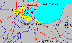
La primera foto de la izquierda muestra un trazado de los primeros waypoints cerca de Tunez.
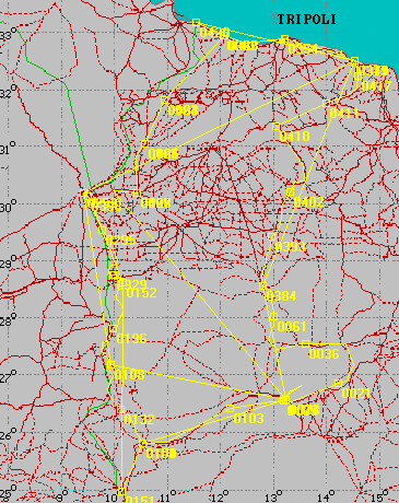
El mapa de abajo es un trazado de todo el fichero OSCAR2.TXT. Mapas más detallados muestran que
las posiciones parecen bastante precisas. Aquí están los datos para los 3 primeros waypoints
cerca de Tunez:
Oscar escribió a Robin un fichero TXT de Waypoint+ el martes 9 de Marzo
(guardado como OSCAR2.TXT), y Robin recibió respuestas de varios contactos sobre el formato
de este fichero (e.g. latitud de 35.1234567 significa 35 grados 12 minutos 34.567 segundos).
El software ha sido modificado para convertir el texto HTML de abajo, y un fichero NME apropiado
para 'reproducir' en los mapas de GPSS.
La primera foto de la izquierda muestra un trazado de los primeros waypoints cerca de Tunez.
El mapa de abajo es un trazado de todo el fichero OSCAR2.TXT. Mapas más detallados muestran que
las posiciones parecen bastante precisas. Aquí están los datos para los 3 primeros waypoints
cerca de Tunez:
Waypoint = Lat/Lon (degs,mins,secs) = degrees = GPSS(15 character) =  Name
1=36°48'56.05"N 10°15'56.73"E=36.81557 10.26576=364893N0101594E=PORTO DE TUNIS
2=36°47'48.91"N 10°06'51.47"E=36.79692 10.1143=364781N0100685E=PONTO CONTROL
3=36°40'37.28"N 10°19'30.29"E=36.67702 10.32508=364062N0101950E=PORTAGEM
En este momento los ficheros TUNISIA.WAW y LIBYA.WAW, que se usan para decir donde estás respecto a las ciudades grandes y los pequeńos pueblos, son muy grandes (miles de pueblos), y puede ralentizarse sobre algún viejo Laptop PC. Quizá hubiera sido más práctico si yo hubiera hecho un fichero WAV (y sonidos WAV) basado en esos waypoints ?
La siguiente actualización de esta página será probablemente para mostrar la ruta planeada.
Aquí están los primeros 3 waypoints de los datos :
Robin can e-mail the whole file to those who contact us with Quiz Answers.
This data has been processed into two files: TL99.GTX suitable for being searched
and used to select the next waypoint as the destination. TL99.NME suitable for
being 'played back' or plotted - to produce the picture on the left, with the
GPSS Control-A DRAW facility. NOTE: the waypoint number
(e.g. 0001) may be different between files. You would normally only use one waypoint
GTX file.
It is best to have learned how to use GPSS before you start the expedition,
using mapping for your home area of Portugal or Spain.
1. first test GPSS works with your GPS connected, and contact Robin by email
to get a 'Snoopy Supression' code. You will need to send your quiz answers.
2. learn how to use the simple facilities in GPSS:
At present the TUNISIA.WAW and LIBYA.WAW files, used to say where you are
relative to major cities and small villages, are very big (thousands of villages), and
may be a little slow on some older Laptop PC. If you have this problem, contact Robin,
who can provide a smaller WAW file, that will not include the small villages.
b. searching a GTX file and use of D key to select a destination. looking at the
Instrument Panel switched on with _ key, and listening to voice guidance.
You may also want to put the most important 10 destinations into GPSS.LOC,
so you can select them with 1D, 2D, etc.
If you are VERY CAREFUL, and you have the time, you may wish to create
suitable ROO files, for automatic change of destination, but this requires
the data to be exactly correct. So it may be best, simply to use the facilities above.
But for those that need to know, here is some information about ROO files.
Route files can have a maximum of 100 waypoints. They must be accurate - i.e.
to within GPS accuracy of 50m to 100m, or better. They must be in the correct
order. i.e. the first waypoint first. When using ROO files, you must drive to within
typically 50 metres of a waypoint in the file, to cause GPSS to automatically select
the next waypoint as the destination - for the Instrument Panel, and voice guidance.
The above are reasons why it is often best not to use ROO files: Easy to make mistakes.
Here is the start of the 99X.ROO file illustrated in the pictures above:
The *R150 at the end of the line, is the Threshold Range in metres, used by
GPSS to automatically switch the destination to the next waypoint. 150m is
a practical value, for use with a normal GPS - which is only accurate to typically
50m to 100m. Making this a bigger value, such as *R500 means less accurate
data can be used, but it means the automatic switch of destination will happen
earlier. e.g. when you are 500m from the waypoint.
Robin can e-mail data in the format needed for a ROO file, as TL99ROUT.TXT
BUT THIS MUST BE BROKEN INTO SMALLER ROO FILES with the correct
sequence of waypoints. If others create these files, they may be available.
To use a ROO file, it must be copied to GPSS.ROO. This could be done
with a number of little .BAT files, with Icons on the Desktop, each with a
simple command like "copy 99roo1.roo gpss.roo". To select that route,
you would then double click on that icon.
But then you must make the Route Guidance in GPSS active. To do that
you hit Control-C, click on the RouteMan button, to get the Route Manager.
You then click on READ to read GPSS.ROO and display the route on the map.
You can then switch on (or off) the automatic Route following.
But Robin stresses - you do not need to use this. Maybe much easier to
use the simple facilities described earlier. i.e. manually select a 'final' destination
for that particular journey, from a GTX file.
Por favor no olvides que GPSS y todos estos datos son usados bajo tu cuenta y riesgo,
Ten cuidado y prudencia cuando viajes.
Waypoint = Lat/Lon (degs,mins,secs) = degrees = GPSS(15 character) =  Name
1=36°48'56.05"N 10°15'56.73"E=36.81557 10.26576=364893N0101594E=PORTO DE TUNIS
2=36°47'48.91"N 10°06'51.47"E=36.79692 10.1143=364781N0100685E=PONTO CONTROL
3=36°40'37.28"N 10°19'30.29"E=36.67702 10.32508=364062N0101950E=PORTAGEM
Here is the same data, converted into a GPSS-compatible TLIBYA99.GTX file:
TLIBYA99.GTX holds waypoints for Trans Libya 99 Event
cat,,location,name,  - note these two lines are comments
L,,364893N0101594E,0001 PORTO DE TUNIS,
L,,364781N0100685E,0002 PONTO CONTROL,
L,,364062N0101950E,0003 PORTAGEM,
Please see the 'Quiz Free Registration' section on
the first Download Page
The picture on the left shows a plot of waypoints in the area of the event, based
on the ordered list of route waypoints e-mailed by Oscar to Robin on Saturday 13th March.
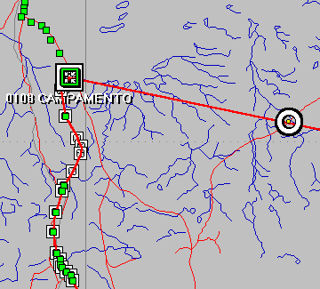
 The map on the left shows a plot of waypoints (in green) and a selection
of wayoints to make a Route (ROO) file (in red). The picture below shows
some of the same information, as shown on the more detailed Libya mapping you can download.
The map on the left shows a plot of waypoints (in green) and a selection
of wayoints to make a Route (ROO) file (in red). The picture below shows
some of the same information, as shown on the more detailed Libya mapping you can download.
Use of GPSS
a. looking at the map, and use of W key - to get 'Where are we ?' response.
Route Files such as 99X.ROO
 45
263395N0131536E *R150
271085N0095694E *R150
271025N0095640E *R150
270917N0095574E *R150
270863N0095544E *R150
etc.
The first line is the number of waypoints in the file. This must be 100 or less.
Then each line holds the GPSS format 15 character lat/lon, in degrees, minutes,
and 1/100ths of minutes. e.g. 263395N = 26 degs 33.95 minutes North.
y no son un sustituto de buenos mapas de papel :-)